
Thank you for supporting this site ❤️
Make a donation
Make a donation
Gear up for your next adventure:
As an Amazon Associate, this site earns from qualifying purchases at no extra cost to you.
Muttom topographic map
Click on the map to display elevation.
Thank you for supporting this site ❤️
Make a donation
Make a donation
Gear up for your next adventure:
As an Amazon Associate, this site earns from qualifying purchases at no extra cost to you.
About this map
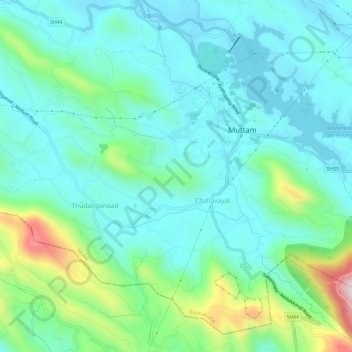
Name: Muttom topographic map, elevation, terrain.
Location: Muttom, Thudanganaad, Thodupuzha, Idukki, Kerala, 685587, India (9.80388 76.70754 9.85683 76.76726)
Average elevation: 152 m
Minimum elevation: 29 m
Maximum elevation: 590 m
Thank you for supporting this site ❤️
Make a donation
Make a donation
Gear up for your next adventure:
As an Amazon Associate, this site earns from qualifying purchases at no extra cost to you.