Geolocate

Clydach topographic map

Click on the map to display elevation.

About this map

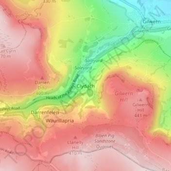
Name: Clydach topographic map, elevation, terrain.

Location: Clydach, Monmouthshire, Wales, NP7 0NF, United Kingdom (51.79049 -3.13771 51.83049 -3.09771)

Average elevation: 325 m

Minimum elevation: 67 m

Maximum elevation: 500 m

Monmouthshire trails, hiking, mountain biking, running and outdoor activities

Other topographic maps

Click on a map to view its topography, its elevation and its terrain.

Llanbadoc

United Kingdom > Wales > Monmouthshire

Average elevation: 78 m

Wye Valley

United Kingdom > Wales > Monmouthshire

Average elevation: 167 m

Penallt

United Kingdom > Wales > Monmouthshire

Average elevation: 174 m

Crucorney

United Kingdom > Wales > Monmouthshire

Average elevation: 297 m

Blorenge

United Kingdom > Wales > Monmouthshire > Govilon

Average elevation: 394 m

River Monnow

United Kingdom > Wales > Monmouthshire

Average elevation: 172 m

River Monnow

United Kingdom > Wales > Monmouthshire

Average elevation: 172 m

Raglan Castle

United Kingdom > Wales > Monmouthshire > Raglan

Average elevation: 59 m

Gear up for your next adventure:

🧰First Aid Kits - Essential safety kits for outdoor activities
🧢Waterproof Hiking Hats - Keep the rain off your face while studying topographic maps
🛰️Satellite Messengers - Emergency communication devices for areas without mobile signal
🔋Power Banks - Portable chargers for long outdoor trips
📱Rugged Phone Cases - Heavy-duty protection for smartphones used as secondary GPS tools

As an Amazon Associate, this site earns from qualifying purchases at no extra cost to you.