
Baidoa District topographic map
Interactive map
Click on the map to display elevation.
About this map
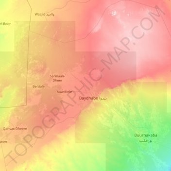
Name: Baidoa District topographic map, elevation, terrain.
Location: Baidoa District, Bay, South West, Somalia (2.52000 43.10000 3.92000 44.31000)
Average elevation: 406 m
Minimum elevation: 133 m
Maximum elevation: 747 m
Other topographic maps
Click on a map to view its topography, its elevation and its terrain.
Baidoa
Somalia > Bay > Baidoa District
Air transportation in Baidoa is served by the Baidoa Airport. Sitting at an elevation of 1,520 feet (463 m), it has a 9843 × 131 ft (3000 × 40 m) asphalt runway. The airport has fuel services, a terminal building, storage container, on-site warehouse, and radio towers.
Average elevation: 435 m