
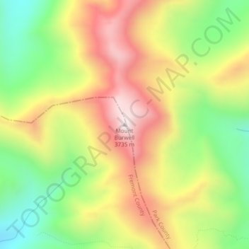
Mount Burwell topographic map
Interactive map
Click on the map to display elevation.
About this map
Name: Mount Burwell topographic map, elevation, terrain.
Location: Mount Burwell, Fremont County, Wyoming, United States (43.92741 -109.44076 43.92751 -109.44066)
Average elevation: 3,387 m
Minimum elevation: 3,062 m
Maximum elevation: 3,731 m
Other topographic maps
Click on a map to view its topography, its elevation and its terrain.
Gannett Peak
United States > Wyoming > Fremont County
Gannett Peak is the highest mountain peak in the U.S. state of Wyoming at 13,810 feet (4,210 m). It lies in the Wind River Range within the Bridger Wilderness of the Bridger-Teton National Forest. Straddling the Continental Divide along the boundary between Fremont and Sublette counties, it has the second…
Average elevation: 3,700 m
Dubois
United States > Wyoming > Fremont County
Dubois is located at 43°32′9″N 109°38′9″W / 43.53583°N 109.63583°W / 43.53583; -109.63583 (43.535936, -109.635915) and an elevation of 2115 m (6940 ft). The Wind River runs through the town.
Average elevation: 2,167 m