
Parque Nacional Tierra del Fuego topographic map
Interactive map
Click on the map to display elevation.
About this map
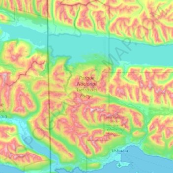
Name: Parque Nacional Tierra del Fuego topographic map, elevation, terrain.
Average elevation: 460 m
Minimum elevation: 0 m
Maximum elevation: 1,470 m
The park has dramatic scenery, with waterfalls, forests, mountains, and glaciers. Its 630 km2 (240 sq mi) include parts of the Fagnano and Roca lakes. The Senda Costera (Coastal Path), connecting Ensenada Bay to Lapataia Bay on Lago Roca, is a popular hiking trail within the park. Forests of Antarctic beech, lenga beech, and coihue in the lower elevations of the park are home to many animal species. There are 20 species of terrestrial mammals, including the guanaco, Andean fox, North American beaver, European rabbit and muskrat. Among the 90 species of birds are the kelp goose, torrent duck, austral parakeet, Andean condor, blackish oystercatcher, and Magellanic oystercatcher.
Other topographic maps
Click on a map to view its topography, its elevation and its terrain.
Tolhuin
Argentina > Tierra del Fuego Province
Tolhuin, Municipio de Tolhuin, Departamento Tolhuin, Tierra del Fuego Province, Argentina
Average elevation: 97 m
Rio Grande
Argentina > Tierra del Fuego Province
Rio Grande, Departamento Río Grande, Tierra del Fuego Province, 9420, Argentina
Average elevation: 23 m
Ushuaia
Argentina > Tierra del Fuego Province > Ushuaia
Ushuaia, Departamento Ushuaia, Tierra del Fuego Province, Argentina
Average elevation: 232 m
Departamento Ushuaia
Argentina > Tierra del Fuego Province
Departamento Ushuaia, Tierra del Fuego Province, Argentina, Laguna del Caminante
Average elevation: 671 m
Rio Grande
Argentina > Tierra del Fuego Province
Rio Grande, Departamento Río Grande, Tierra del Fuego Province, 9420, Argentina
Average elevation: 6 m