
Make a donation
Gear up for your next adventure:
As an Amazon Associate, this site earns from qualifying purchases at no extra cost to you.
Jodhpur topographic map
Click on the map to display elevation.
Make a donation
Gear up for your next adventure:
As an Amazon Associate, this site earns from qualifying purchases at no extra cost to you.
About this map
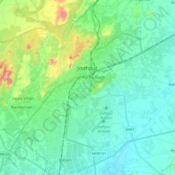
Name: Jodhpur topographic map, elevation, terrain.
Location: Jodhpur, Jodhpur Tehsil, Jodhpur, Rajasthan, India (26.20598 72.94858 26.35367 73.08887)
Average elevation: 238 m
Minimum elevation: 197 m
Maximum elevation: 398 m
Make a donation
Gear up for your next adventure:
As an Amazon Associate, this site earns from qualifying purchases at no extra cost to you.
Other topographic maps
Click on a map to view its topography, its elevation and its terrain.
(Shree Pravshnath park )Prabhu Pravshnath nagar pal balaji
India > Rajasthan > Jodhpur Tehsil > Jodhpur
Average elevation: 231 m
Make a donation
Gear up for your next adventure:
As an Amazon Associate, this site earns from qualifying purchases at no extra cost to you.