
Mount Carmel Township topographic map
Interactive map
Click on the map to display elevation.
About this map
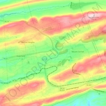
Name: Mount Carmel Township topographic map, elevation, terrain.
Average elevation: 389 m
Minimum elevation: 241 m
Maximum elevation: 551 m
Other topographic maps
Click on a map to view its topography, its elevation and its terrain.
Dalmatia
United States > Pennsylvania > Northumberland County > Lower Mahanoy Township
Average elevation: 172 m
Atlas
United States > Pennsylvania > Northumberland County > Mount Carmel Township
Average elevation: 385 m
Overlook
United States > Pennsylvania > Northumberland County > Ralpho Township
Average elevation: 261 m
Snufftown
United States > Pennsylvania > Northumberland County > Ralpho Township
Average elevation: 215 m