Iford topographic map
Interactive map
Click on the map to display elevation.
About this map
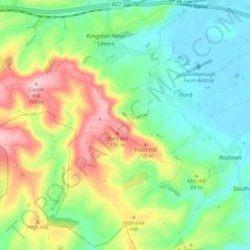
Name: Iford topographic map, elevation, terrain.
Location: Iford, Lewes, East Sussex, South East, England, United Kingdom (50.82088 -0.04600 50.86349 0.03483)
Average elevation: 72 m
Minimum elevation: -2 m
Maximum elevation: 201 m
Other topographic maps
Click on a map to view its topography, its elevation and its terrain.
Rodmell
United Kingdom > England > Lewes
Rodmell, Lewes, East Sussex, South East, England, United Kingdom
Average elevation: 47 m
Winterbourne
United Kingdom > England > Lewes
Winterbourne, Lewes, East Sussex, South East, England, BN7 1HW, United Kingdom
Average elevation: 35 m
Ouse Valley
United Kingdom > England > Lewes
Ouse Valley, Seaford Road, Newhaven, Lewes, East Sussex, South East, England, BN9 0LP, United Kingdom
Average elevation: 15 m
Wivelsfield
United Kingdom > England > Lewes
Wivelsfield, Lewes, East Sussex, South East, England, United Kingdom
Average elevation: 48 m
Piddinghoe
United Kingdom > England > Lewes
Piddinghoe, Lewes, East Sussex, South East, England, United Kingdom
Average elevation: 27 m