Geolocate

Mamut topographic map

Click on the map to display elevation.

About this map

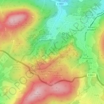
Name: Mamut topographic map, elevation, terrain.

Location: Mamut, Jonsdorf, Olbersdorf, Görlitz, Saxony, 02796, Germany (50.84663 14.69031 50.84673 14.69041)

Average elevation: 519 m

Minimum elevation: 400 m

Maximum elevation: 639 m

Gear up for your next adventure:

👖Convertible Hiking Trousers - Versatile zip-off pants for changing mountain weather conditions
🛰️Satellite Messengers - Emergency communication devices for areas without mobile signal
👕Merino Base Layers - Natural temperature regulation for cold weather hiking and camping
🐕Hiking Dog Harnesses - Rugged harnesses for taking your companion on mountain trails
❄️Walking Crampons - Added traction for icy slopes and winter peak bagging

As an Amazon Associate, this site earns from qualifying purchases at no extra cost to you.