
Montalban topographic map
Interactive map
Click on the map to display elevation.
About this map
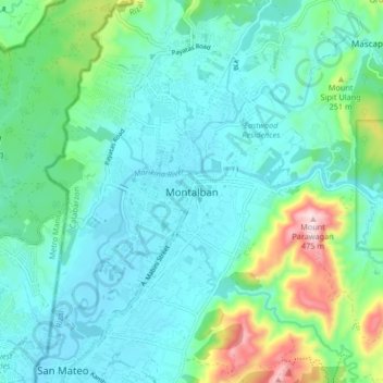
Name: Montalban topographic map, elevation, terrain.
Location: Montalban, Rizal, Calabarzon, 1860, Philippines (14.69247 121.10527 14.77247 121.18527)
Average elevation: 99 m
Minimum elevation: 8 m
Maximum elevation: 459 m
Other topographic maps
Click on a map to view its topography, its elevation and its terrain.
Pantok
Philippines > Rizal > Binangonan
Pantok, Binangonan, Rizal, Calabarzon, 1903, Philippines
Average elevation: 28 m
Talim Island
Philippines > Rizal > Ginoong Sanay
Talim Island, Ginoong Sanay, Rizal, Calabarzon, Philippines
Average elevation: 13 m
Marikina River
Marikina River, Eastern Manila District, Rizal, Metro Manila, Philippines
Average elevation: 88 m
Muzon
Philippines > Rizal > Taytay
Muzon, Taytay, Rizal, Calabarzon, 1920, Philippines
Average elevation: 28 m
Plaza Aldea
Plaza Aldea, Rizal, Calabarzon, 1970, Philippines
Average elevation: 12 m
Maries Village II Phase 2
Maries Village II Phase 2, Mayamot, Rizal, Calabarzon, 1871, Philippines
Average elevation: 38 m
Dela Paz
Philippines > Rizal > Antipolo
Dela Paz, Antipolo, Rizal, Calabarzon, 1870, Philippines
Average elevation: 85 m
Cainta
Philippines > Rizal > Cainta > Cainta
Cainta, Rizal, Calabarzon, 190, Philippines
Average elevation: 24 m
Inarawan
Philippines > Rizal > Inarawan
Inarawan, Rizal, Calabarzon, 1879, Philippines
Average elevation: 215 m
Mayamot
Philippines > Rizal > Mayamot
Mayamot, Rizal, Calabarzon, 1871, Philippines
Average elevation: 26 m
Mabato
Philippines > Rizal > Binangonan > Pantok
Mabato, Pantok, Binangonan, Rizal, Calabarzon, 1903, Philippines
Average elevation: 38 m
Pintong Bocaue
Philippines > Rizal > Pintong Bocaue
Pintong Bocaue, Rizal, Calabarzon, Philippines
Average elevation: 297 m
Binangonan
Binangonan, Rizal, Calabarzon, 1940, Philippines
Average elevation: 21 m
San Jose
Philippines > Rizal > San Jose
San Jose, Rizal, Calabarzon, 1631, Philippines
Average elevation: 39 m
Kalawaan
Philippines > Rizal > Kalawaan
Kalawaan, Rizal, Calabarzon, 01940, Philippines
Average elevation: 26 m
San Isidro
Philippines > Rizal > San Isidro
San Isidro, Rizal, Calabarzon, 1631, Philippines
Average elevation: 71 m
Muzon
Philippines > Rizal > Taytay > Muzon
Muzon, Taytay, Rizal, 1920, Philippines
Average elevation: 32 m
Cupang
Philippines > Rizal > Cupang
Cupang, Rizal, Calabarzon, 1873, Philippines
Average elevation: 81 m
Sitio Propito
Philippines > Rizal > Antipolo > Sitio Propito
Sitio Propito, Antipolo, Rizal, Calabarzon, 1870, Philippines
Average elevation: 293 m
Angono
Philippines > Rizal > Angono
Angono, Rizal, Calabarzon, 1930, Philippines
Average elevation: 47 m
Sampaloc
Philippines > Rizal > Sampaloc
Sampaloc, Rizal, Calabarzon, 1964, Philippines
Average elevation: 391 m
Amiya Raya
Philippines > Rizal > Amiya Raya
Amiya Raya, Rizal, Calabarzon, 1850, Philippines
Average elevation: 152 m
Mount Ayaas
Philippines > Rizal > Antipolo
Mount Ayaas, Antipolo, Rizal, Calabarzon, 1870, Philippines
Average elevation: 294 m
Santa Ana
Philippines > Rizal > Santa Ana
Santa Ana, Taytay, Rizal, Calabarzon, 1920J, Philippines
Average elevation: 5 m
Santa Cruz
Philippines > Rizal > Antipolo
Santa Cruz, Antipolo, Rizal, Calabarzon, 1870, Philippines
Average elevation: 140 m
Bilibiran
Philippines > Rizal > Bilibiran
Bilibiran, Rizal, Calabarzon, 01940, Philippines
Average elevation: 23 m