
Make a donation
Gear up for your next adventure:
As an Amazon Associate, this site earns from qualifying purchases at no extra cost to you.
Berchtesgaden topographic map
Click on the map to display elevation.
Make a donation
Gear up for your next adventure:
As an Amazon Associate, this site earns from qualifying purchases at no extra cost to you.
About this map
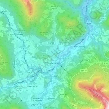
Name: Berchtesgaden topographic map, elevation, terrain.
Average elevation: 834 m
Minimum elevation: 486 m
Maximum elevation: 2,364 m
Make a donation
Gear up for your next adventure:
As an Amazon Associate, this site earns from qualifying purchases at no extra cost to you.
Other topographic maps
Click on a map to view its topography, its elevation and its terrain.
Obersalzberg
Germany > Bavaria > Landkreis Berchtesgadener Land > Berchtesgaden > Untersalzberg I
Average elevation: 933 m
Oberjettenberg
Germany > Bavaria > Landkreis Berchtesgadener Land > Schneizlreuth
Average elevation: 792 m
Mayerhofen
Germany > Bavaria > Landkreis Berchtesgadener Land > Laufen > Oberheining
Average elevation: 418 m
Make a donation
Gear up for your next adventure:
As an Amazon Associate, this site earns from qualifying purchases at no extra cost to you.
Untersalzberg I
Germany > Bavaria > Landkreis Berchtesgadener Land > Berchtesgaden
Average elevation: 758 m
Laufen (Salzach)
Germany > Bavaria > Landkreis Berchtesgadener Land > Laufen > Laufen (Salzach)
Average elevation: 431 m