
Val-Fouzon topographic map
Interactive map
Click on the map to display elevation.
About this map
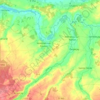
Name: Val-Fouzon topographic map, elevation, terrain.
Average elevation: 105 m
Minimum elevation: 72 m
Maximum elevation: 148 m
Other topographic maps
Click on a map to view its topography, its elevation and its terrain.
Varennes-sur-Fouzon
France > Centre-Val de Loire > Indre > Val-Fouzon
Varennes-sur-Fouzon, Val-Fouzon, Issoudun, Indre, Centre-Val de Loire, France métropolitaine, 36210, France
Average elevation: 100 m
Varennes-sur-Fouzon
France > Centre-Val de Loire > Indre > Val-Fouzon
Varennes-sur-Fouzon, Val-Fouzon, Issoudun, Indre, Centre-Val de Loire, France métropolitaine, 36210, France
Average elevation: 108 m