
Kętrzyn County topographic map
Interactive map
Click on the map to display elevation.
About this map
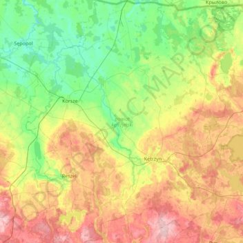
Name: Kętrzyn County topographic map, elevation, terrain.
Location: Kętrzyn County, Warmian-Masurian Voivodeship, Poland (53.93819 21.02201 54.33482 21.60231)
Average elevation: 93 m
Minimum elevation: 25 m
Maximum elevation: 214 m
Other topographic maps
Click on a map to view its topography, its elevation and its terrain.
Iława
Poland > Warmian-Masurian Voivodeship > Iława County > Iława
Iława, Iława County, Warmian-Masurian Voivodeship, 14-200, Poland
Average elevation: 107 m
Pasłęk
Poland > Warmian-Masurian Voivodeship > Elbląg County
Pasłęk, gmina Pasłęk, Elbląg County, Warmian-Masurian Voivodeship, 14-400, Poland
Average elevation: 35 m
Ronin
Poland > Warmian-Masurian Voivodeship > Braniewo County
Ronin, gmina Frombork, Braniewo County, Warmian-Masurian Voivodeship, 14-530, Poland
Average elevation: 19 m
Bogumiły
Poland > Warmian-Masurian Voivodeship > Pisz County
Bogumiły, gmina Pisz, Pisz County, Warmian-Masurian Voivodeship, 12-200, Poland
Average elevation: 129 m
Czaple
Poland > Warmian-Masurian Voivodeship > Ełk County
Czaple, gmina Ełk, Ełk County, Warmian-Masurian Voivodeship, 19-311, Poland
Average elevation: 140 m
Rogity
Poland > Warmian-Masurian Voivodeship > Braniewo County
Rogity, gmina Braniewo, Braniewo County, Warmian-Masurian Voivodeship, 14-500, Poland
Average elevation: 14 m
Szymbark
Poland > Warmian-Masurian Voivodeship > Iława County
Szymbark, gmina Iława, Iława County, Warmian-Masurian Voivodeship, Poland
Average elevation: 105 m
Drewnowo
Poland > Warmian-Masurian Voivodeship > Braniewo County
Drewnowo, gmina Frombork, Braniewo County, Warmian-Masurian Voivodeship, 14-530, Poland
Average elevation: 32 m
Płoskinia
Poland > Warmian-Masurian Voivodeship > Braniewo County
Płoskinia, gmina Płoskinia, Braniewo County, Warmian-Masurian Voivodeship, 14-526, Poland
Average elevation: 68 m
Jędrychowo
Poland > Warmian-Masurian Voivodeship > Mrągowo County
Jędrychowo, gmina Sorkwity, Mrągowo County, Warmian-Masurian Voivodeship, 11-731, Poland
Average elevation: 149 m
Krasnolipie
Poland > Warmian-Masurian Voivodeship > Braniewo County
Krasnolipie, gmina Braniewo, Braniewo County, Warmian-Masurian Voivodeship, 14-500, Poland
Average elevation: 100 m
Kruklanki
Poland > Warmian-Masurian Voivodeship > Giżycko County
Kruklanki, gmina Kruklanki, Giżycko County, Warmian-Masurian Voivodeship, Poland
Average elevation: 137 m
Olsztyn
Poland > Warmian-Masurian Voivodeship > Olsztyn
Olsztyn, Warmian-Masurian Voivodeship, Poland
Average elevation: 123 m
Ułowo
Poland > Warmian-Masurian Voivodeship > Braniewo County > Ułowo
Ułowo, gmina Braniewo, Braniewo County, Warmian-Masurian Voivodeship, 14-500, Poland
Average elevation: 1 m
Różyna
Poland > Warmian-Masurian Voivodeship > Bartoszyce County > Różyna
Różyna, gmina Sępopol, Bartoszyce County, Warmian-Masurian Voivodeship, 11-210, Poland
Average elevation: 41 m
Żuławki
Poland > Warmian-Masurian Voivodeship > Ostróda County > Żuławki
Żuławki, gmina Ostróda, Ostróda County, Warmian-Masurian Voivodeship, Poland
Average elevation: 211 m
Mrągowo County
Poland > Warmian-Masurian Voivodeship
Mrągowo County, Warmian-Masurian Voivodeship, Poland
Average elevation: 141 m
Opin
Poland > Warmian-Masurian Voivodeship > Opin
Opin, gmina Orneta, Lidzbark County, Warmian-Masurian Voivodeship, 11-130, Poland
Average elevation: 78 m
Pisz County
Poland > Warmian-Masurian Voivodeship
Pisz County, Warmian-Masurian Voivodeship, Poland
Average elevation: 134 m
Węgorzewo County
Poland > Warmian-Masurian Voivodeship
Węgorzewo County, Warmian-Masurian Voivodeship, Poland
Average elevation: 119 m
Giżycko County
Poland > Warmian-Masurian Voivodeship
Giżycko County, Warmian-Masurian Voivodeship, Poland
Average elevation: 134 m
Dąbrówka Mała
Poland > Warmian-Masurian Voivodeship > Dąbrówka Mała
Dąbrówka Mała, gmina Orzysz, Pisz County, Warmian-Masurian Voivodeship, Poland
Average elevation: 130 m
Olsztyn County
Poland > Warmian-Masurian Voivodeship
Olsztyn County, Warmian-Masurian Voivodeship, Poland
Average elevation: 140 m
Elk
Poland > Warmian-Masurian Voivodeship > Elk
Elk, powiat ełcki, Warmian-Masurian Voivodeship, Poland
Average elevation: 129 m
Pieniężno
Poland > Warmian-Masurian Voivodeship > Braniewo County
Pieniężno, gmina Pieniężno, Braniewo County, Warmian-Masurian Voivodeship, Poland
Average elevation: 89 m
Milejewo
Poland > Warmian-Masurian Voivodeship > Milejewo
Milejewo, gmina Milejewo, powiat elbląski, Warmian-Masurian Voivodeship, 82-316, Poland
Average elevation: 171 m
Pagórki
Poland > Warmian-Masurian Voivodeship > Pagórki
Pagórki, gmina Tolkmicko, powiat elbląski, Warmian-Masurian Voivodeship, 82-340, Poland
Average elevation: 165 m
Pakosze
Poland > Warmian-Masurian Voivodeship > Pakosze
Pakosze, gmina Pieniężno, Braniewo County, Warmian-Masurian Voivodeship, 14-520, Poland
Average elevation: 115 m
Mamry
Poland > Warmian-Masurian Voivodeship > Węgorzewo
Mamry, Braci Ejsmontów, Węgorzewo, gmina Węgorzewo, powiat węgorzewski, Warmian-Masurian Voivodeship, 11-600, Poland
Average elevation: 117 m
Spychowo
Poland > Warmian-Masurian Voivodeship > Spychowo
Spychowo, gmina Świętajno, Szczytno County, Warmian-Masurian Voivodeship, 12-140, Poland
Average elevation: 135 m
Węgorzewo
Poland > Warmian-Masurian Voivodeship > Węgorzewo County
Węgorzewo, gmina Węgorzewo, Węgorzewo County, Warmian-Masurian Voivodeship, Poland
Average elevation: 123 m
Sztynort
Poland > Warmian-Masurian Voivodeship > Węgorzewo County > Sztynort
Sztynort, gmina Węgorzewo, Węgorzewo County, Warmian-Masurian Voivodeship, 11-600, Poland
Average elevation: 117 m
Karolewo
Poland > Warmian-Masurian Voivodeship > Karolewo
Karolewo, gmina Kętrzyn, powiat kętrzyński, Warmian-Masurian Voivodeship, 11-400, Poland
Average elevation: 112 m
Olsztynek
Poland > Warmian-Masurian Voivodeship > Olsztynek
Olsztynek, gmina Olsztynek, powiat olsztyński, Warmian-Masurian Voivodeship, 11-015, Poland
Average elevation: 174 m
Pasym
Poland > Warmian-Masurian Voivodeship > Pasym
Pasym, gmina Pasym, Szczytno County, Warmian-Masurian Voivodeship, 12-130, Poland
Average elevation: 143 m
Kruklanki
Poland > Warmian-Masurian Voivodeship > Giżycko County > Kruklanki
Kruklanki, gmina Kruklanki, Giżycko County, Warmian-Masurian Voivodeship, 11-612, Poland
Average elevation: 136 m
Gołdap
Poland > Warmian-Masurian Voivodeship > Gołdap
Gołdap, gmina Gołdap, powiat gołdapski, Warmian-Masurian Voivodeship, Poland
Average elevation: 167 m
Szczytno
Poland > Warmian-Masurian Voivodeship > Szczytno County > Szczytno
Szczytno, Szczytno County, Warmian-Masurian Voivodeship, 12-100, Poland
Average elevation: 151 m
Mrągowo
Poland > Warmian-Masurian Voivodeship > Mrągowo > Mrągowo
Mrągowo, powiat mrągowski, Warmian-Masurian Voivodeship, 11-700, Poland
Average elevation: 150 m
Ostróda
Poland > Warmian-Masurian Voivodeship > Ostróda
Ostróda, powiat ostródzki, Warmian-Masurian Voivodeship, Poland
Average elevation: 106 m
Pietrasze
Poland > Warmian-Masurian Voivodeship > Pietrasze
Pietrasze, gmina Gołdap, Gołdap County, Warmian-Masurian Voivodeship, Poland
Average elevation: 261 m