
Greenwater topographic map
Interactive map
Click on the map to display elevation.
Greenwater
Greenwater is located at the confluence of the Greenwater and White Rivers, at an approximate elevation of 1,700 feet (520 m) above sea level.
About this map
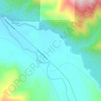
Name: Greenwater topographic map, elevation, terrain.
Location: Greenwater, Pierce County, Washington, United States (47.13115 -121.66028 47.15871 -121.60101)
Average elevation: 655 m
Minimum elevation: 512 m
Maximum elevation: 1,165 m
Other topographic maps
Click on a map to view its topography, its elevation and its terrain.
Mount Rainier
United States > Washington > Pierce County
Mount Rainier (/reɪˈnɪər/ ray-NEER), also known as Tahoma, is a large active stratovolcano in the Cascade Range of the Pacific Northwest in the United States. The mountain is located in Mount Rainier National Park about 59 miles (95 km) south-southeast of Seattle. With an officially recognized summit…
Average elevation: 3,911 m
Mount Rainier
United States > Washington > Pierce County
Mount Rainier (/reɪˈnɪər/ ray-NEER), also known as Tahoma, is a large active stratovolcano in the Cascade Range of the Pacific Northwest in the United States. The mountain is located in Mount Rainier National Park about 59 miles (95 km) south-southeast of Seattle. With a summit elevation of 14,411 ft…
Average elevation: 3,911 m
Mount Rainier
United States > Washington > Pierce County
Mount Rainier (/reɪˈnɪər/), indigenously known as Tahoma, Tacoma, Tacobet, or təqʷubəʔ, is a large active stratovolcano in the Cascade Range of the Pacific Northwest, located in Mount Rainier National Park about 59 miles (95 km) south-southeast of Seattle. With a summit elevation of 14,411 ft (4,392…
Average elevation: 3,911 m
Gig Harbor
United States > Washington > Pierce County > Gig Harbor > Gig Harbor
Average elevation: 49 m