
Lac Pemichangan topographic map
Interactive map
Click on the map to display elevation.
About this map
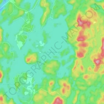
Name: Lac Pemichangan topographic map, elevation, terrain.
Average elevation: 207 m
Minimum elevation: 146 m
Maximum elevation: 351 m
Other topographic maps
Click on a map to view its topography, its elevation and its terrain.
Mont Sainte-Marie
Canada > Québec > La Vallée-de-la-Gatineau > Lac-Sainte-Marie
Mont Sainte-Marie, Lac-Sainte-Marie, La Vallée-de-la-Gatineau, Outaouais, Québec, J0X 1Z0, Canada
Average elevation: 351 m