
Milton Keynes topographic map
Interactive map
Click on the map to display elevation.
About this map
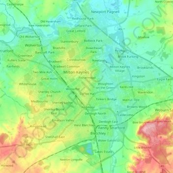
Name: Milton Keynes topographic map, elevation, terrain.
Location: Milton Keynes, City of Milton Keynes, England, United Kingdom (51.96989 -0.86349 52.08927 -0.65063)
Average elevation: 90 m
Minimum elevation: 52 m
Maximum elevation: 178 m
Other topographic maps
Click on a map to view its topography, its elevation and its terrain.
Caldecotte Lake
United Kingdom > England > City of Milton Keynes > Milton Keynes > Fenny Stratford
Caldecotte Lake, Walton, Fenny Stratford, Milton Keynes, City of Milton Keynes, England, United Kingdom
Average elevation: 75 m
Walton Lake
United Kingdom > England > City of Milton Keynes > Milton Keynes > Monkston
Walton Lake, Woughton on the Green, Old Woughton, Monkston, Milton Keynes, City of Milton Keynes, England, United Kingdom
Average elevation: 73 m
Shenley Church End
United Kingdom > England > City of Milton Keynes > Milton Keynes
Shenley Church End, Milton Keynes, City of Milton Keynes, England, United Kingdom
Average elevation: 98 m
Furzton Lake
United Kingdom > England > City of Milton Keynes > Milton Keynes > Bletchley
Furzton Lake, Furzton, Bletchley, Milton Keynes, City of Milton Keynes, England, United Kingdom
Average elevation: 93 m
Shenley Brook End
United Kingdom > England > City of Milton Keynes > Milton Keynes
Shenley Brook End, Milton Keynes, City of Milton Keynes, England, United Kingdom
Average elevation: 105 m