
德兴乡 topographic map
Interactive map
Click on the map to display elevation.
About this map
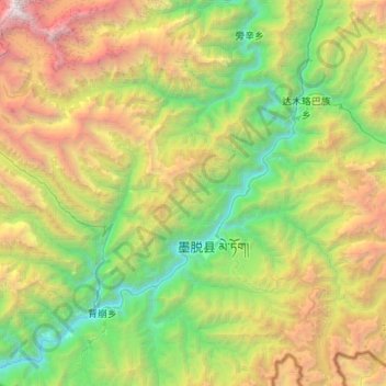
Name: 德兴乡 topographic map, elevation, terrain.
Location: 德兴乡, 墨脱县, 林芝市, 西藏自治区, 中国 (29.25430 94.89819 29.52811 95.44111)
Average elevation: 2,700 m
Minimum elevation: 597 m
Maximum elevation: 7,203 m
德兴乡(藏語:བདེ་ཞིང།,威利转写:bde zhing)是中国西藏自治区墨脱县下辖的一个乡,位于墨脱县城西面,隔雅鲁藏布江与县城毗邻。2007年人口296户,1554人,以门巴族为主。全乡平均海拔1200米,经济以农业为主,2007年农作物播种面积4392.51亩,主要种植玉米、水稻、鸡爪谷等。下辖7个村委会:德兴村、巴登则村、德果村、荷扎村、文浪村、易贡白村、那儿东村,乡政府驻德兴村。
Other topographic maps
Click on a map to view its topography, its elevation and its terrain.