Geolocate

Ahiazu-Mbaise topographic map

Interactive map

Click on the map to display elevation.

About this map

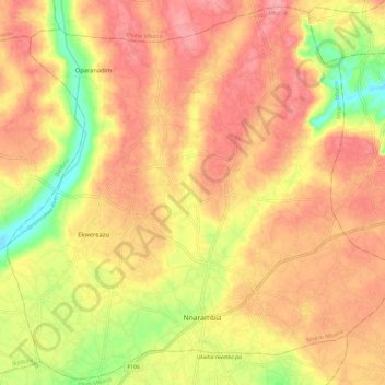
Name: Ahiazu-Mbaise topographic map, elevation, terrain.

Location: Ahiazu-Mbaise, Imo State, Nigeria (5.50604 7.20697 5.61927 7.32448)

Average elevation: 150 m

Minimum elevation: 90 m

Maximum elevation: 186 m

Other topographic maps

Click on a map to view its topography, its elevation and its terrain.

Ubomiri

Nigeria > Imo State > Mbaitoli

Average elevation: 94 m

Ihiagwa

Nigeria > Imo State > Owerri West

Average elevation: 60 m

Akabo

Nigeria > Imo State > Mbaitoli

Average elevation: 127 m

Emii

Nigeria > Imo State > Owerri North

Average elevation: 94 m

Owerri

Nigeria > Imo State > Owerri Municipal

Average elevation: 88 m

Owerri

Nigeria > Imo State > Owerri Municipal

Average elevation: 88 m