
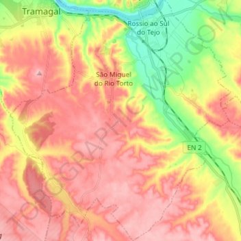
São Miguel do Rio Torto e Rossio ao Sul do Tejo topographic map
Interactive map
Click on the map to display elevation.
About this map
Name: São Miguel do Rio Torto e Rossio ao Sul do Tejo topographic map, elevation, terrain.
Average elevation: 115 m
Minimum elevation: 14 m
Maximum elevation: 188 m
Other topographic maps
Click on a map to view its topography, its elevation and its terrain.
São Miguel do Rio Torto
Portugal > Santarém > Abrantes
São Miguel do Rio Torto, Abrantes, Santarém, Portugal
Average elevation: 119 m
Arreciadas
Portugal > Santarém > Abrantes
Arreciadas, São Miguel do Rio Torto e Rossio ao Sul do Tejo, Abrantes, Santarém, 2205-013, Portugal
Average elevation: 86 m