
Chapman topographic map
Interactive map
Click on the map to display elevation.
About this map
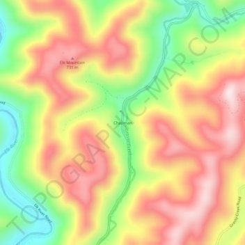
Name: Chapman topographic map, elevation, terrain.
Location: Chapman, Webster County, West Virginia, 26217, United States (38.52511 -80.48064 38.56511 -80.44064)
Average elevation: 578 m
Minimum elevation: 333 m
Maximum elevation: 784 m
Other topographic maps
Click on a map to view its topography, its elevation and its terrain.
Addison (Webster Springs)
United States > West Virginia > Webster County
Webster Springs is located at 38°28′34″N 80°24′36″W / 38.47611°N 80.41000°W / 38.47611; -80.41000 (38.476192, -80.410025), along the Elk River. According to the United States Census Bureau, the town has a total area of 0.47 square miles (1.22 km2), of which 0.45 square miles (1.17 km2) is…
Average elevation: 600 m