
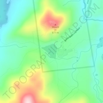
Heart Lake topographic map
Interactive map
Click on the map to display elevation.
About this map
Name: Heart Lake topographic map, elevation, terrain.
Average elevation: 690 m
Minimum elevation: 590 m
Maximum elevation: 904 m
Other topographic maps
Click on a map to view its topography, its elevation and its terrain.
Village of Lake Placid
United States > New York > Essex County
Village of Lake Placid, Town of North Elba, Essex County, New York, 12946, United States
Average elevation: 558 m
Ray Brook
United States > New York > Essex County
Ray Brook, Town of North Elba, Essex County, New York, 12977, United States
Average elevation: 526 m
Keene Valley
United States > New York > Essex County > Town of Keene
Keene Valley, Town of Keene, Essex County, New York, 12943, United States
Average elevation: 459 m
Grover Hills
United States > New York > Essex County > Mineville
Grover Hills, Mineville, Town of Moriah, Essex County, New York, 12956, United States
Average elevation: 315 m
Town of Lewis
United States > New York > Essex County
Town of Lewis, Essex County, New York, 12950, United States
Average elevation: 352 m
Saint Huberts
United States > New York > Essex County > Town of Keene
Saint Huberts, Town of Keene, Essex County, New York, 12943, United States
Average elevation: 536 m
Town of Saint Armand
United States > New York > Essex County
Town of Saint Armand, Essex County, New York, 12913, United States
Average elevation: 577 m
Town of Elizabethtown
United States > New York > Essex County
Town of Elizabethtown, Essex County, New York, United States
Average elevation: 406 m
Witherbee
United States > New York > Essex County > Town of Moriah
Witherbee, Town of Moriah, Essex County, New York, 12998, United States
Average elevation: 376 m
Craterclub
United States > New York > Essex County
Craterclub, Town of Essex, Essex County, New York, 12936, United States
Average elevation: 50 m
Rome
United States > New York > Essex County > Town of Jay
Rome, Town of Jay, Essex County, New York, 12912, United States
Average elevation: 237 m
Deerhead
United States > New York > Essex County > Town of Lewis
Deerhead, Town of Lewis, Essex County, New York, United States
Average elevation: 253 m
Port Douglass
United States > New York > Essex County
Port Douglass, Town of Chesterfield, Essex County, New York, 12975, United States
Average elevation: 110 m
Town of Essex
United States > New York > Essex County
Town of Essex, Essex County, New York, 12936, United States
Average elevation: 71 m
Port Kent
United States > New York > Essex County
Port Kent, Town of Chesterfield, Essex County, New York, 12975, United States
Average elevation: 63 m
Boquet
United States > New York > Essex County
Boquet, Town of Essex, Essex County, New York, 12936, United States
Average elevation: 112 m
Whallonsburg
United States > New York > Essex County
Whallonsburg, Town of Essex, Essex County, New York, 12936, United States
Average elevation: 104 m
Green Street
United States > New York > Essex County > Town of Jay
Green Street, Town of Jay, Essex County, New York, United States
Average elevation: 320 m
Stowersville
United States > New York > Essex County > Town of Lewis
Stowersville, Town of Lewis, Essex County, New York, 12950, United States
Average elevation: 183 m
AuSable Chasm
United States > New York > Essex County
AuSable Chasm, Town of Chesterfield, Essex County, New York, 12911, United States
Average elevation: 110 m
Burdick Crossing
United States > New York > Essex County > Town of Crown Point
Burdick Crossing, Town of Crown Point, Essex County, New York, 12928, United States
Average elevation: 41 m
Cold Spring Park
United States > New York > Essex County > Town of Crown Point
Cold Spring Park, Town of Crown Point, Essex County, New York, 12928, United States
Average elevation: 256 m
Crown Point Center
United States > New York > Essex County > Town of Crown Point
Crown Point Center, Town of Crown Point, Essex County, New York, 12928, United States
Average elevation: 158 m
Factoryville
United States > New York > Essex County > Town of Crown Point
Factoryville, Town of Crown Point, Essex County, New York, 12928, United States
Average elevation: 126 m
Ironville
United States > New York > Essex County > Town of Crown Point
Ironville, Town of Crown Point, Essex County, New York, United States
Average elevation: 326 m
Glenmore
United States > New York > Essex County > Town of Keene
Glenmore, Town of Keene, Essex County, New York, 12942, United States
Average elevation: 648 m
North Jay
United States > New York > Essex County > Town of Jay
North Jay, Town of Jay, Essex County, New York, United States
Average elevation: 263 m
Crowningshield
United States > New York > Essex County > Town of Lewis
Crowningshield, Town of Lewis, Essex County, New York, United States
Average elevation: 183 m
Aiden Lair
United States > New York > Essex County
Aiden Lair, Town of Minerva, Essex County, New York, United States
Average elevation: 563 m
Boreas River
United States > New York > Essex County
Boreas River, Essex County, New York, United States
Average elevation: 575 m
The Grove
United States > New York > Essex County > Town of Jay
The Grove, Town of Jay, Essex County, New York, United States
Average elevation: 240 m
Town of Chesterfield
United States > New York > Essex County
Town of Chesterfield, Essex County, New York, United States
Average elevation: 195 m
Bloomingdale
United States > New York > Essex County
Bloomingdale, Town of Saint Armand, Essex County, New York, 12913, United States
Average elevation: 490 m
Town of Crown Point
United States > New York > Essex County
Town of Crown Point, Essex County, New York, 12928, United States
Average elevation: 164 m
Giant Mountain
United States > New York > Essex County > Town of Keene
Giant Mountain, Town of Keene, Essex County, New York, United States
Average elevation: 1,060 m
Town of Westport
United States > New York > Essex County
Town of Westport, Essex County, New York, 12993, United States
Average elevation: 151 m
Bear Mountain
United States > New York > Essex County > Town of Ticonderoga
Bear Mountain, Town of Ticonderoga, Essex County, New York, 12883, United States
Average elevation: 173 m
Upper Jay
United States > New York > Essex County > Town of Jay
Upper Jay, Town of Jay, Essex County, New York, 12987, United States
Average elevation: 323 m
Paradox
United States > New York > Essex County
Paradox, Town of Schroon, Essex County, New York, 12858, United States
Average elevation: 322 m
Town of North Elba
United States > New York > Essex County
Town of North Elba, Essex County, New York, United States
Average elevation: 728 m
Whiteface Mountain
United States > New York > Essex County > Town of Wilmington
Whiteface Mountain, Town of Wilmington, Essex County, New York, United States
Average elevation: 1,090 m
Whiteface
United States > New York > Essex County
Whiteface, Town of North Elba, Essex County, New York, 12946, United States
Average elevation: 636 m
Town of North Hudson
United States > New York > Essex County
Town of North Hudson, Essex County, New York, 12855, United States
Average elevation: 539 m
Blue Ridge Mountain
United States > New York > Essex County > Town of North Hudson
Blue Ridge Mountain, Town of North Hudson, Essex County, New York, United States
Average elevation: 818 m
Olmstedville
United States > New York > Essex County
Olmstedville, Town of Minerva, Essex County, New York, 12857, United States
Average elevation: 379 m
Schroon Lake
United States > New York > Essex County > Schroon Lake
Schroon Lake, Essex County, New York, 12870, United States
Average elevation: 290 m
Keeseville
United States > New York > Essex County
Keeseville, Town of Chesterfield, Essex County, New York, 12944, United States
Average elevation: 150 m
Town of Moriah
United States > New York > Essex County
Town of Moriah, Essex County, New York, United States
Average elevation: 283 m
Town of Newcomb
United States > New York > Essex County
Town of Newcomb, Essex County, New York, 12852, United States
Average elevation: 627 m
Town of Minerva
United States > New York > Essex County
Town of Minerva, Essex County, New York, United States
Average elevation: 528 m