
Souday topographic map
Interactive map
Click on the map to display elevation.
About this map
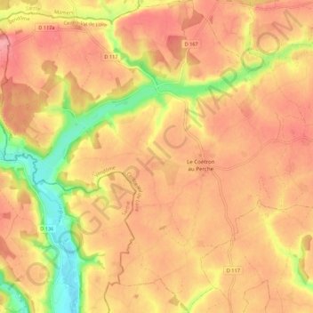
Name: Souday topographic map, elevation, terrain.
Average elevation: 157 m
Minimum elevation: 101 m
Maximum elevation: 186 m
Other topographic maps
Click on a map to view its topography, its elevation and its terrain.
Oigny
France > Centre-Val de Loire > Loir-et-Cher > Couëtron-au-Perche
Oigny, Couëtron-au-Perche, Vendôme, Loir-et-Cher, Centre-Val de Loire, France métropolitaine, 41170, France
Average elevation: 171 m
Oigny
France > Centre-Val de Loire > Loir-et-Cher > Couëtron-au-Perche
Oigny, Couëtron-au-Perche, Vendôme, Loir-et-Cher, Centre-Val de Loire, France métropolitaine, 41170, France
Average elevation: 168 m
Saint-Agil
France > Centre-Val de Loire > Loir-et-Cher > Couëtron-au-Perche
Saint-Agil, Couëtron-au-Perche, Vendôme, Loir-et-Cher, Centre-Val de Loire, France métropolitaine, 41170, France
Average elevation: 175 m