
Make a donation
Gear up for your next adventure:
As an Amazon Associate, this site earns from qualifying purchases at no extra cost to you.
Dover topographic map
Click on the map to display elevation.
Make a donation
Gear up for your next adventure:
As an Amazon Associate, this site earns from qualifying purchases at no extra cost to you.
About this map
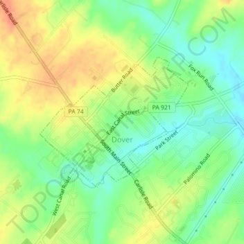
Name: Dover topographic map, elevation, terrain.
Location: Dover, York County, Pennsylvania, 17315, United States (39.99616 -76.85922 40.01061 -76.83772)
Average elevation: 137 m
Minimum elevation: 116 m
Maximum elevation: 159 m
Make a donation
Gear up for your next adventure:
As an Amazon Associate, this site earns from qualifying purchases at no extra cost to you.
Other topographic maps
Click on a map to view its topography, its elevation and its terrain.
Rosemount
United States > Pennsylvania > York County > Spring Garden Township
Average elevation: 167 m
Make a donation
Gear up for your next adventure:
As an Amazon Associate, this site earns from qualifying purchases at no extra cost to you.
Hanover Junction
United States > Pennsylvania > York County > North Codorus Township
Average elevation: 187 m
Strickhousers
United States > Pennsylvania > York County > North Codorus Township
Average elevation: 205 m
Make a donation
Gear up for your next adventure:
As an Amazon Associate, this site earns from qualifying purchases at no extra cost to you.
Bass Lake
United States > Pennsylvania > York County > Newberry Township > Valley Green
Average elevation: 143 m
Starview
United States > Pennsylvania > York County > East Manchester Township
Average elevation: 155 m
Make a donation
Gear up for your next adventure:
As an Amazon Associate, this site earns from qualifying purchases at no extra cost to you.
Pleasureville
United States > Pennsylvania > York County > Springettsbury Township
Average elevation: 145 m
East York
United States > Pennsylvania > York County > Springettsbury Township
Average elevation: 143 m
Make a donation
Gear up for your next adventure:
As an Amazon Associate, this site earns from qualifying purchases at no extra cost to you.
Stoverstown
United States > Pennsylvania > York County > North Codorus Township
Average elevation: 171 m
Spring Plains
United States > Pennsylvania > York County > Springettsbury Township
Average elevation: 151 m
Make a donation
Gear up for your next adventure:
As an Amazon Associate, this site earns from qualifying purchases at no extra cost to you.
Spring Plains
United States > Pennsylvania > York County > Springettsbury Township
Average elevation: 151 m
Make a donation
Gear up for your next adventure:
As an Amazon Associate, this site earns from qualifying purchases at no extra cost to you.
Delta Ridge
United States > Pennsylvania > York County > Peach Bottom Township
Average elevation: 150 m
Make a donation
Gear up for your next adventure:
As an Amazon Associate, this site earns from qualifying purchases at no extra cost to you.
Ore Valley
United States > Pennsylvania > York County > York Township > Ore Valley
Average elevation: 202 m