
San Cristóbal topographic map
Interactive map
Click on the map to display elevation.
About this map
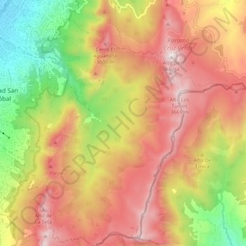
Name: San Cristóbal topographic map, elevation, terrain.
Location: San Cristóbal, Bogotá, Distrito Capital, Colombia (4.50863 -74.10663 4.58933 -74.02839)
Average elevation: 3,168 m
Minimum elevation: 2,581 m
Maximum elevation: 3,663 m
Other topographic maps
Click on a map to view its topography, its elevation and its terrain.
San Cristóbal
Colombia > Distrito Capital > San Cristóbal
San Cristóbal, Bogotá, Distrito Capital, 111711, Colombia
Average elevation: 3,008 m