
Punta Gennedidu topographic map
Interactive map
Click on the map to display elevation.
About this map
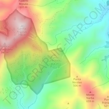
Name: Punta Gennedidu topographic map, elevation, terrain.
Location: Punta Gennedidu, San Vito, Sud Sardegna, Sardegna, 09040, Italia (39.40922 9.50612 39.40932 9.50622)
Average elevation: 361 m
Minimum elevation: 66 m
Maximum elevation: 764 m
Other topographic maps
Click on a map to view its topography, its elevation and its terrain.
Arcu Mannu
Arcu Mannu, San Vito, Sud Sardegna, Sardegna, 09040, Italia
Average elevation: 155 m