
Oleiros topographic map
Interactive map
Click on the map to display elevation.
About this map
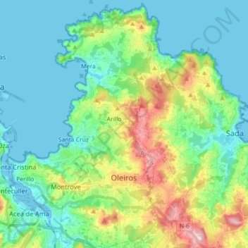
Name: Oleiros topographic map, elevation, terrain.
Location: Oleiros, A Coruña, Galicië, Spanje (43.30385 -8.38372 43.40698 -8.29570)
Average elevation: 49 m
Minimum elevation: -1 m
Maximum elevation: 188 m
Other topographic maps
Click on a map to view its topography, its elevation and its terrain.
Pena Sombreira
Pena Sombreira, Culleredo, A Coruña, Galicië, 15198, Spanje
Average elevation: 244 m