
Redoubt topographic map
Interactive map
Click on the map to display elevation.
About this map
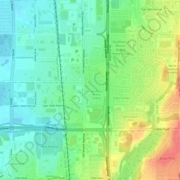
Name: Redoubt topographic map, elevation, terrain.
Location: Redoubt, Anchorage, Alaska, United States (61.12863 -149.86364 61.12945 -149.86028)
Average elevation: 49 m
Minimum elevation: 26 m
Maximum elevation: 87 m
Other topographic maps
Click on a map to view its topography, its elevation and its terrain.
Anchorage
United States > Alaska > Anchorage
Anchorage, Alaska, 99501, United States
Average elevation: 124 m
Chugiak
United States > Alaska > Anchorage
Chugiak, Anchorage, Alaska, United States
Average elevation: 295 m
Chugach Meadows
United States > Alaska > Anchorage > Anchorage
Chugach Meadows, Anchorage, Alaska, United States
Average elevation: 46 m
Alyeska
United States > Alaska > Anchorage > Girdwood
Alyeska, Girdwood, Anchorage, Alaska, 99523, United States
Average elevation: 256 m
South Yuyanq’ Ch’ex
United States > Alaska > Anchorage
South Yuyanq’ Ch’ex, Anchorage, Alaska, United States
Average elevation: 1,071 m
Knik Arm
United States > Alaska > Anchorage
Knik Arm, Anchorage, Alaska, United States
Average elevation: 72 m
Powder Ridge
United States > Alaska > Anchorage
Powder Ridge, Anchorage, Alaska, United States
Average elevation: 89 m
Girdwood
United States > Alaska > Anchorage
Girdwood, Anchorage, Alaska, 99587, United States
Average elevation: 181 m