
Make a donation
Gear up for your next adventure:
As an Amazon Associate, this site earns from qualifying purchases at no extra cost to you.
Loray topographic map
Click on the map to display elevation.
Make a donation
Gear up for your next adventure:
As an Amazon Associate, this site earns from qualifying purchases at no extra cost to you.
Loray
Loray est une commune de l'est de la France, près de Pierrefontaine-les-Varans, Valdahon, Orchamps-Vennes à environ 43 km à l'est de Besançon, sur la Route des micro-techniques entre Morteau et Besançon. Son point culminant est la Roche-Barchey à environ 1 000 m d'altitude. Altitude marquée.
Make a donation
Gear up for your next adventure:
As an Amazon Associate, this site earns from qualifying purchases at no extra cost to you.
About this map
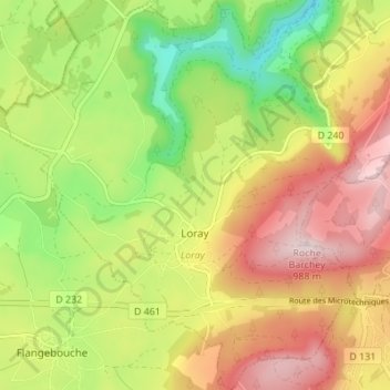
Name: Loray topographic map, elevation, terrain.
Average elevation: 753 m
Minimum elevation: 545 m
Maximum elevation: 968 m
Make a donation
Gear up for your next adventure:
As an Amazon Associate, this site earns from qualifying purchases at no extra cost to you.
Other topographic maps
Click on a map to view its topography, its elevation and its terrain.
Make a donation
Gear up for your next adventure:
As an Amazon Associate, this site earns from qualifying purchases at no extra cost to you.
Sous les Queuteux
France > Bourgogne-Franche-Comté > Doubs > Ornans > Sous les Queuteux
Average elevation: 434 m
Make a donation
Gear up for your next adventure:
As an Amazon Associate, this site earns from qualifying purchases at no extra cost to you.