
San Felipe topographic map
Interactive map
Click on the map to display elevation.
About this map
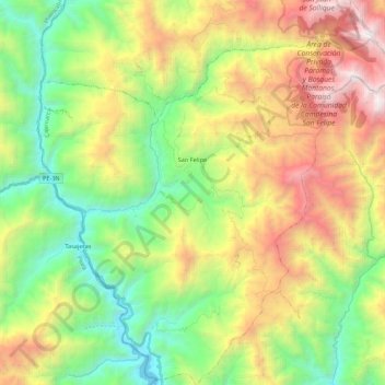
Name: San Felipe topographic map, elevation, terrain.
Location: San Felipe, Jaén, Cajamarca, Perú (-5.89684 -79.40084 -5.68096 -79.20005)
Average elevation: 2,106 m
Minimum elevation: 1,093 m
Maximum elevation: 3,694 m
Other topographic maps
Click on a map to view its topography, its elevation and its terrain.
Provincia de Jaén
Provincia de Jaén, Chontalí, Jaén, Cajamarca, Perú
Average elevation: 1,768 m
Río Magdalena
Río Magdalena, Chilete, Contumazá, Cajamarca, Perú
Average elevation: 1,499 m