
Lac de Liantran topographic map
Interactive map
Click on the map to display elevation.
About this map
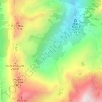
Name: Lac de Liantran topographic map, elevation, terrain.
Average elevation: 2,123 m
Minimum elevation: 1,640 m
Maximum elevation: 2,715 m
Other topographic maps
Click on a map to view its topography, its elevation and its terrain.
Col d'Ilhéou
France > Occitanie > Hautes-Pyrénées > Estaing
Col d'Ilhéou, Estaing, Argelès-Gazost, Hautes-Pyrénées, Occitanie, France métropolitaine, 65400, France
Average elevation: 2,203 m
Les Colonies
France > Occitanie > Hautes-Pyrénées > Estaing
Les Colonies, Estaing, Argelès-Gazost, Hautes-Pyrénées, Occitanie, France métropolitaine, 65400, France
Average elevation: 1,557 m
Lac d'Estaing
France > Occitanie > Hautes-Pyrénées > Estaing
Lac d'Estaing, Estaing, Argelès-Gazost, Hautes-Pyrénées, Occitanie, France métropolitaine, 65400, France
Average elevation: 1,507 m