
Thank you for supporting this site ❤️
Make a donation
Make a donation
Gear up for your next adventure:
As an Amazon Associate, this site earns from qualifying purchases at no extra cost to you.
Laguna topographic map
Click on the map to display elevation.
Thank you for supporting this site ❤️
Make a donation
Make a donation
Gear up for your next adventure:
As an Amazon Associate, this site earns from qualifying purchases at no extra cost to you.
About this map
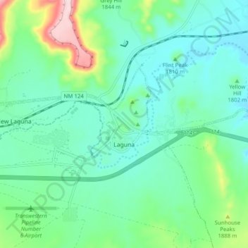
Name: Laguna topographic map, elevation, terrain.
Location: Laguna, Cibola County, New Mexico, United States (35.02606 -107.44582 35.05478 -107.36840)
Average elevation: 1,804 m
Minimum elevation: 1,741 m
Maximum elevation: 2,015 m
Thank you for supporting this site ❤️
Make a donation
Make a donation
Gear up for your next adventure:
As an Amazon Associate, this site earns from qualifying purchases at no extra cost to you.
Other topographic maps
Click on a map to view its topography, its elevation and its terrain.
Rio Grande Rift Historical Marker
United States > New Mexico > Cibola County > Laguna
Average elevation: 1,782 m