
Stresa topographic map
Interactive map
Click on the map to display elevation.
About this map
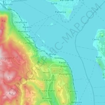
Name: Stresa topographic map, elevation, terrain.
Location: Stresa, Verbano-Cusio-Ossola, Piedmont, Italy (45.85155 8.44636 45.91858 8.58693)
Average elevation: 387 m
Minimum elevation: 173 m
Maximum elevation: 1,145 m
Other topographic maps
Click on a map to view its topography, its elevation and its terrain.
Ghiacciaio del Belvedere
Italy > Piedmont > Verbano-Cusio-Ossola > Macugnaga
Average elevation: 2,211 m
Alpe Cheggio
Italy > Piedmont > Verbano-Cusio-Ossola > Antrona Schieranco > Alpe Cheggio
Average elevation: 1,830 m