
Thank you for supporting this site ❤️
Make a donation
Make a donation
Gear up for your next adventure:
As an Amazon Associate, this site earns from qualifying purchases at no extra cost to you.
Isinya topographic map
Click on the map to display elevation.
Thank you for supporting this site ❤️
Make a donation
Make a donation
Gear up for your next adventure:
As an Amazon Associate, this site earns from qualifying purchases at no extra cost to you.
About this map
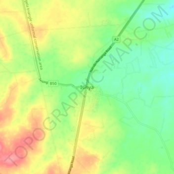
Name: Isinya topographic map, elevation, terrain.
Location: Isinya, Kaputiei North ward, Kajiado East, Rift Valley, Kenya (-1.72597 36.80667 -1.64597 36.88667)
Average elevation: 1,654 m
Minimum elevation: 1,620 m
Maximum elevation: 1,699 m
Thank you for supporting this site ❤️
Make a donation
Make a donation
Gear up for your next adventure:
As an Amazon Associate, this site earns from qualifying purchases at no extra cost to you.