
Mittelgebirge topographic map
Interactive map
Click on the map to display elevation.
About this map
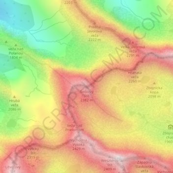
Name: Mittelgebirge topographic map, elevation, terrain.
Average elevation: 2,015 m
Minimum elevation: 1,477 m
Maximum elevation: 2,464 m
Other topographic maps
Click on a map to view its topography, its elevation and its terrain.
Rabenstein
Slowakei > Eperieser Landschaftsverband > Bezirk Deutschendorf > Uhrngarten
Rabenstein, Uhrngarten, Bezirk Deutschendorf, Eperieser Landschaftsverband, Ostslowakei, 059 56, Slowakei
Average elevation: 1,624 m