
Make a donation
Gear up for your next adventure:
As an Amazon Associate, this site earns from qualifying purchases at no extra cost to you.
Evolène topographic map
Click on the map to display elevation.
Make a donation
Gear up for your next adventure:
As an Amazon Associate, this site earns from qualifying purchases at no extra cost to you.
Evolène
At precisely 8.27 pm, the first two avalanches were set off on the slopes above Villa, at an altitude around 2,600 m (8,500 ft). They were a combination of fresh powder snow and established spring snow and demolished all trees and chalets in their path, as well as the people unlucky enough to be in the chalets at the time. The two avalanches continued to run along the extremities of Villa and eventually formed as one massive fusion of snow and debris reaching up to 15 m (49 ft) high that came to rest 1,000 m (3,300 ft) down the slope, after taking 12 lives and cutting off the main road between Evolène and des Haudères.
Make a donation
Gear up for your next adventure:
As an Amazon Associate, this site earns from qualifying purchases at no extra cost to you.
About this map
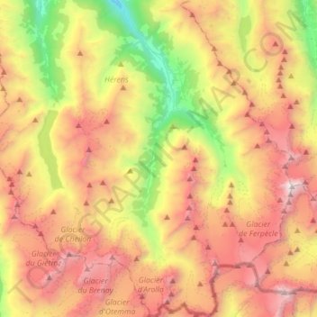
Name: Evolène topographic map, elevation, terrain.
Location: Evolène, Hérens, Wallis, 1983, Switzerland (45.95490 7.42553 46.14706 7.61195)
Average elevation: 2,697 m
Minimum elevation: 1,129 m
Maximum elevation: 4,350 m
Make a donation
Gear up for your next adventure:
As an Amazon Associate, this site earns from qualifying purchases at no extra cost to you.
Other topographic maps
Click on a map to view its topography, its elevation and its terrain.
Mase
Switzerland > Wallis > Hérens > Mont-Noble
The village is located in the Hérens district on the right bank of the Borgne and the left bank of the Rhone in the Val d'Hérens at an elevation of 1,345 m (4,413 ft). It consists of the village of Mase.
Average elevation: 1,272 m
Make a donation
Gear up for your next adventure:
As an Amazon Associate, this site earns from qualifying purchases at no extra cost to you.
Make a donation
Gear up for your next adventure:
As an Amazon Associate, this site earns from qualifying purchases at no extra cost to you.
Make a donation
Gear up for your next adventure:
As an Amazon Associate, this site earns from qualifying purchases at no extra cost to you.
Make a donation
Gear up for your next adventure:
As an Amazon Associate, this site earns from qualifying purchases at no extra cost to you.