Lac de Tseuzier topographic map
Interactive map
Click on the map to display elevation.
About this map
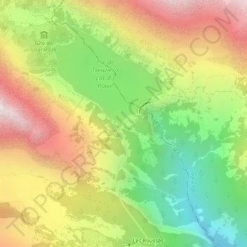
Name: Lac de Tseuzier topographic map, elevation, terrain.
Location: Lac de Tseuzier, Ayent, Hérens, Wallis, 1966, Switzerland (46.33548 7.42324 46.35548 7.44324)
Average elevation: 1,871 m
Minimum elevation: 1,224 m
Maximum elevation: 2,576 m
Other topographic maps
Click on a map to view its topography, its elevation and its terrain.
Schnidehorn
Switzerland > Wallis > Hérens > Ayent
Schnidehorn, Ayent, Hérens, Wallis, 1966, Switzerland
Average elevation: 2,566 m
Bonnefille
Switzerland > Wallis > Hérens > Ayent > Anzère
Bonnefille, Anzère, Ayent, Hérens, Wallis, 1972, Switzerland
Average elevation: 1,408 m
Wildhorn
Switzerland > Wallis > Hérens > Ayent
Wildhorn, Ayent, Hérens, Wallis, 1966, Switzerland
Average elevation: 2,768 m
Anzère
Switzerland > Wallis > Hérens > Ayent
Anzère, Ayent, Hérens, Wallis, 1972, Switzerland
Average elevation: 1,493 m