
Palangos miesto savivaldybė topographic map
Interactive map
Click on the map to display elevation.
About this map
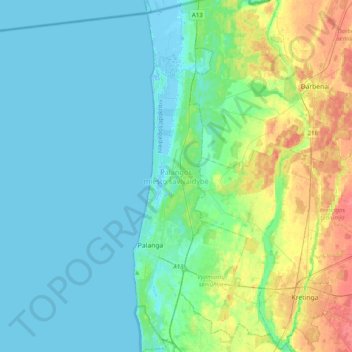
Name: Palangos miesto savivaldybė topographic map, elevation, terrain.
Location: Palangos miesto savivaldybė, Bezirk Memel, Litauen (55.85518 21.04893 56.07717 21.13892)
Average elevation: 11 m
Minimum elevation: -4 m
Maximum elevation: 45 m
Das Stadtkreisgericht Palanga ist die unterste Instanz der Rechtsprechung in Palanga. Die nächsthöhere Instanz ist das Bezirksgericht Klaipėda.
Other topographic maps
Click on a map to view its topography, its elevation and its terrain.
Mataičiai
Litauen > Bezirk Memel > Judrėnų seniūnija
Mataičiai, Judrėnų seniūnija, Rajongemeinde Memel, Bezirk Memel, 96291, Litauen
Average elevation: 90 m
Karten
Litauen > Bezirk Memel > Kartenos seniūnija
Karten, Kartenos seniūnija, Kretingos rajono savivaldybė, Bezirk Memel, 97351, Litauen
Average elevation: 56 m
Klaipeda
Klaipeda, Stadtgemeinde Memel, Bezirk Memel, Litauen
Average elevation: 9 m
Polangen
Polangen, Palangos miesto savivaldybė, Bezirk Memel, Litauen
Average elevation: 9 m
Schoden
Litauen > Bezirk Memel > Schoden
Schoden, Skuodo miesto seniūnija, Skuodo rajono savivaldybė, Bezirk Memel, Litauen
Average elevation: 24 m