
Fargo topographic map
Interactive map
Click on the map to display elevation.
About this map
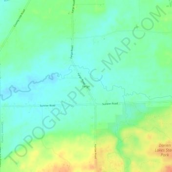
Name: Fargo topographic map, elevation, terrain.
Average elevation: 266 m
Minimum elevation: 252 m
Maximum elevation: 293 m
Other topographic maps
Click on a map to view its topography, its elevation and its terrain.
Lehigh
United States > New York > Genesee County > Town of Darien
Lehigh, Town of Darien, Genesee County, New York, 14056, United States
Average elevation: 279 m
Griswold
United States > New York > Genesee County > Town of Darien
Griswold, Town of Darien, Genesee County, New York, 14040, United States
Average elevation: 334 m
Longwood
United States > New York > Genesee County > Town of Darien
Longwood, Town of Darien, Genesee County, New York, 14036, United States
Average elevation: 272 m
Darien Center
United States > New York > Genesee County > Town of Darien
Darien Center, Town of Darien, Genesee County, New York, 14040, United States
Average elevation: 307 m