
La Pirotte topographic map
Interactive map
Click on the map to display elevation.
About this map
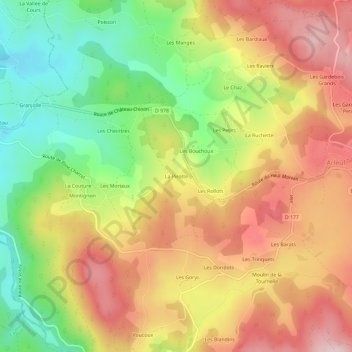
Name: La Pirotte topographic map, elevation, terrain.
Average elevation: 552 m
Minimum elevation: 398 m
Maximum elevation: 695 m
Other topographic maps
Click on a map to view its topography, its elevation and its terrain.
Les Pasquelins
France > Bourgogne-Franche-Comté > Nièvre > Arleuf
Les Pasquelins, Arleuf, Château-Chinon (Ville), Nièvre, Bourgogne-Franche-Comté, France métropolitaine, 58430, France
Average elevation: 647 m
Les Robins
France > Bourgogne-Franche-Comté > Nièvre > Arleuf
Les Robins, Arleuf, Château-Chinon (Ville), Nièvre, Bourgogne-Franche-Comté, France métropolitaine, 58430, France
Average elevation: 535 m
Le Marault
France > Bourgogne-Franche-Comté > Nièvre > Arleuf
Le Marault, Arleuf, Château-Chinon (Ville), Nièvre, Bourgogne-Franche-Comté, France métropolitaine, 58430, France
Average elevation: 668 m
Les Brenots
France > Bourgogne-Franche-Comté > Nièvre > Arleuf
Les Brenots, Arleuf, Château-Chinon (Ville), Nièvre, Bourgogne-Franche-Comté, France métropolitaine, 58430, France
Average elevation: 657 m
Les Raviers
France > Bourgogne-Franche-Comté > Nièvre > Arleuf
Les Raviers, Arleuf, Château-Chinon (Ville), Nièvre, Bourgogne-Franche-Comté, France métropolitaine, 58430, France
Average elevation: 592 m
Les Brenets
France > Bourgogne-Franche-Comté > Nièvre > Arleuf
Les Brenets, Arleuf, Château-Chinon (Ville), Nièvre, Bourgogne-Franche-Comté, France métropolitaine, 58430, France
Average elevation: 638 m