
Make a donation
Gear up for your next adventure:
As an Amazon Associate, this site earns from qualifying purchases at no extra cost to you.
Reckwitz topographic map
Click on the map to display elevation.
Make a donation
Gear up for your next adventure:
As an Amazon Associate, this site earns from qualifying purchases at no extra cost to you.
Reckwitz
Die ursprünglich bereits 1850 errichtete Talsperre Döllnitzsee wurde Anfang der 1980er Jahre als Ersatz für den Elsterstausee rekonstruiert, der durch tagebauliche Inanspruchnahme verkleinert wurde. Zusätzlich zum Damm wurde ein bis zu 5 Meter hoher und 665 Meter langer Schutzdamm errichtet, da der Wasserspiegel höher ist als Teile der Reckwitzer Grundstücke.
Make a donation
Gear up for your next adventure:
As an Amazon Associate, this site earns from qualifying purchases at no extra cost to you.
About this map
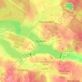
Name: Reckwitz topographic map, elevation, terrain.
Location: Reckwitz, Wermsdorf, Nordsachsen, Sachsen, 04779, Deutschland (51.25061 12.91487 51.29061 12.95487)
Average elevation: 181 m
Minimum elevation: 132 m
Maximum elevation: 207 m
Make a donation
Gear up for your next adventure:
As an Amazon Associate, this site earns from qualifying purchases at no extra cost to you.
Other topographic maps
Click on a map to view its topography, its elevation and its terrain.