
Ras Umlil topographic map
Interactive map
Click on the map to display elevation.
About this map
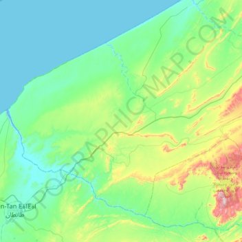
Name: Ras Umlil topographic map, elevation, terrain.
Average elevation: 148 m
Minimum elevation: -4 m
Maximum elevation: 813 m
Other topographic maps
Click on a map to view its topography, its elevation and its terrain.
Ras Umlil
Marokko > Cercle de Laqsabi دائرة القصابي > Ras Umlil
Ras Umlil, Caïdat de Labyar قيادة البيار, Cercle de Laqsabi دائرة القصابي, Province de Guelmim ⵜⴰⵙⴳⴰ ⵏ ⴳⵍⵎⵉⵎ إقليم كلميم, Kulmim-Wadi Nun, Marokko
Average elevation: 197 m