
Make a donation
Gear up for your next adventure:
As an Amazon Associate, this site earns from qualifying purchases at no extra cost to you.
Isla Cozumel topographic map
Click on the map to display elevation.
Make a donation
Gear up for your next adventure:
As an Amazon Associate, this site earns from qualifying purchases at no extra cost to you.
Isla Cozumel
Large parts of the island are covered with mangrove forest which has many endemic animal species. Cozumel is a flat island based on limestone, resulting in a karst topography. The highest natural point on the island is less than 15 m (49 ft) above sea level. The cenotes are water-filled sinkholes formed by water percolating through the soft limestone soil for thousands of years. Eighteen deep cenotes and more than 250 shallow bodies exist on the island. Many are under dense vegetation. Jade Cavern Cozumel (Cenote Chempita) near El Cedral is often visited by tourists.
Make a donation
Gear up for your next adventure:
As an Amazon Associate, this site earns from qualifying purchases at no extra cost to you.
About this map
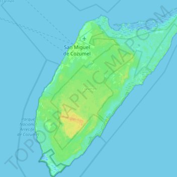
Name: Isla Cozumel topographic map, elevation, terrain.
Location: Isla Cozumel, Cozumel, Quintana Roo, Mexico (20.27200 -87.02520 20.59200 -86.72328)
Average elevation: 2 m
Minimum elevation: -3 m
Maximum elevation: 18 m
Make a donation
Gear up for your next adventure:
As an Amazon Associate, this site earns from qualifying purchases at no extra cost to you.