
Paso Internacional Los Libertadores topographic map
Interactive map
Click on the map to display elevation.
About this map
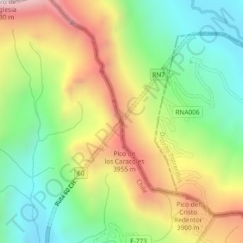
Name: Paso Internacional Los Libertadores topographic map, elevation, terrain.
Average elevation: 3,583 m
Minimum elevation: 3,172 m
Maximum elevation: 4,146 m
Other topographic maps
Click on a map to view its topography, its elevation and its terrain.
Aconcagua
Argentina > Mendoza > Distrito Las Cuevas
Aconcagua, Distrito Las Cuevas, Departamento Las Heras, Mendoza, Argentina
Average elevation: 6,201 m