
Penton Mewsey topographic map
Interactive map
Click on the map to display elevation.
About this map
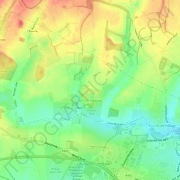
Name: Penton Mewsey topographic map, elevation, terrain.
Location: Penton Mewsey, Test Valley, Hampshire, England, United Kingdom (51.20959 -1.53566 51.24676 -1.50851)
Average elevation: 91 m
Minimum elevation: 64 m
Maximum elevation: 120 m
Hampshire trails, hiking, mountain biking, running and outdoor activities
Other topographic maps
Click on a map to view its topography, its elevation and its terrain.
Bath Meadows
United Kingdom > England > Hampshire > Test Valley > Wellow > East Wellow
Average elevation: 30 m
News Wood
United Kingdom > England > Hampshire > Test Valley > King's Somborne
Average elevation: 93 m
Bitterne Grove
United Kingdom > England > Hampshire > Test Valley > Mottisfont > Dunbridge
Average elevation: 39 m
Rockmoor Pond
United Kingdom > England > Hampshire > Test Valley > Littledown
Average elevation: 208 m
Charlton Down
United Kingdom > England > Hampshire > Test Valley > Wildhern > Charlton Down
Average elevation: 111 m
The Bog
United Kingdom > England > Hampshire > Test Valley > Braishfield > Crookhill
Average elevation: 39 m