
Gauderndorf topographic map
Interactive map
Click on the map to display elevation.
About this map
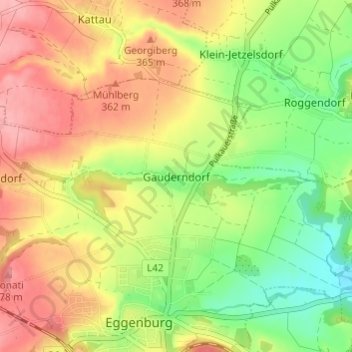
Name: Gauderndorf topographic map, elevation, terrain.
Average elevation: 330 m
Minimum elevation: 274 m
Maximum elevation: 384 m
Other topographic maps
Click on a map to view its topography, its elevation and its terrain.
Eggenburg
Austria > Lower Austria > Bezirk Horn > Gemeinde Eggenburg > Eggenburg
Eggenburg, Gemeinde Eggenburg, Bezirk Horn, Lower Austria, 3730, Austria
Average elevation: 343 m
Eggenburg
Austria > Lower Austria > Bezirk Horn > Gemeinde Eggenburg > Eggenburg
Eggenburg, Gemeinde Eggenburg, Bezirk Horn, Lower Austria, 3730, Austria
Average elevation: 352 m