Geolocate

Gwynedd topographic map

Click on the map to display elevation.

About this map

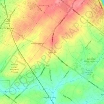
Name: Gwynedd topographic map, elevation, terrain.

Location: Gwynedd, Lower Gwynedd Township, Montgomery County, Pennsylvania, 19436, United States (40.18177 -75.27518 40.22177 -75.23518)

Average elevation: 111 m

Minimum elevation: 67 m

Maximum elevation: 150 m

Gear up for your next adventure:

🔦Head Torches - Hands-free lighting for hiking and camping
👖Convertible Hiking Trousers - Versatile zip-off pants for changing mountain weather conditions
🧣Neck Gaiters - Protects against wind and sun on exposed ridges and peaks
🔦Keychain LED Torches - Emergency backup light for finding gear in your pack
🥾Men's Waterproof Hiking Boots - Durable footwear with deep lugs for muddy and rocky UK terrains

As an Amazon Associate, this site earns from qualifying purchases at no extra cost to you.