
Gefrees topographic map
Interactive map
Click on the map to display elevation.
About this map
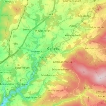
Name: Gefrees topographic map, elevation, terrain.
Location: Gefrees, Landkreis Bayreuth, Bavaria, 95482, Germany (50.04970 11.67457 50.13393 11.81840)
Average elevation: 585 m
Minimum elevation: 385 m
Maximum elevation: 851 m
Other topographic maps
Click on a map to view its topography, its elevation and its terrain.
Fichtelberg
Germany > Bavaria > Landkreis Bayreuth
Fichtelberg, Landkreis Bayreuth, Bavaria, 95686, Germany
Average elevation: 697 m
Gottelhof
Germany > Bavaria > Landkreis Bayreuth > Hollfeld
Gottelhof, Hollfeld, Hollfeld (VGem), Landkreis Bayreuth, Bavaria, 95515, Germany
Average elevation: 407 m
Röhrig
Germany > Bavaria > Landkreis Bayreuth > Bindlacher Berg
Röhrig, Bindlacher Berg, Bindlach, Landkreis Bayreuth, Bavaria, 95463, Germany
Average elevation: 410 m
Plech
Germany > Bavaria > Landkreis Bayreuth
Plech, Betzenstein (VGem), Landkreis Bayreuth, Bavaria, 91287, Germany
Average elevation: 475 m