
Veliki Izvor topographic map
Interactive map
Click on the map to display elevation.
About this map
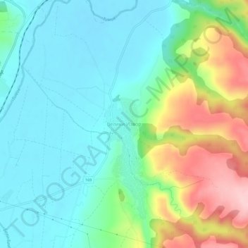
Name: Veliki Izvor topographic map, elevation, terrain.
Average elevation: 175 m
Minimum elevation: 114 m
Maximum elevation: 320 m
Other topographic maps
Click on a map to view its topography, its elevation and its terrain.
Sokobanja
Serbia > Central Serbia > Zajecar Administrative District > Sokobanja Municipality
Sokobanja, Sokobanja Municipality, Zajecar Administrative District, Central Serbia, 18230, Serbia
Average elevation: 509 m
Boljevac Municipality
Serbia > Central Serbia > Zajecar Administrative District
Boljevac Municipality, Zajecar Administrative District, Central Serbia, Serbia, Rtanj
Average elevation: 1,065 m