
Uranium City topographic map
Interactive map
Click on the map to display elevation.
About this map
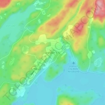
Name: Uranium City topographic map, elevation, terrain.
Location: Uranium City, Division No. 18, Saskatchewan, Kanada (59.54911 -108.63633 59.58911 -108.59633)
Average elevation: 282 m
Minimum elevation: 236 m
Maximum elevation: 392 m
Uranium City litt unter denselben Problemen wie andere monostrukturelle Gemeinden. Die Entwicklung der Stadt hing von der Urannachfrage ab und erlebte mehrere Höhen und Tiefen, bis 1982 die letzte Grube schloss. In anderen Gebieten Saskatchewans (McArthur River, Cigar Lake) wurden höhere Urananteile im Gestein gefunden und der Abbau in Uranium City daher eingestellt.
Other topographic maps
Click on a map to view its topography, its elevation and its terrain.
Ile-à-la-Crosse
Kanada > Saskatchewan > Division No. 18
Ile-à-la-Crosse, Division No. 18, Saskatchewan, S0M 1C0, Kanada
Average elevation: 423 m