
Make a donation
Gear up for your next adventure:
As an Amazon Associate, this site earns from qualifying purchases at no extra cost to you.
Ramsey Island topographic map
Click on the map to display elevation.
Make a donation
Gear up for your next adventure:
As an Amazon Associate, this site earns from qualifying purchases at no extra cost to you.
About this map
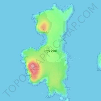
Name: Ramsey Island topographic map, elevation, terrain.
Location: Ramsey Island, St Davids, Pembrokeshire, Wales, United Kingdom (51.85378 -5.35330 51.87915 -5.32967)
Average elevation: 14 m
Minimum elevation: -1 m
Maximum elevation: 130 m
Pembrokeshire trails, hiking, mountain biking, running and outdoor activities
Make a donation
Gear up for your next adventure:
As an Amazon Associate, this site earns from qualifying purchases at no extra cost to you.
Other topographic maps
Click on a map to view its topography, its elevation and its terrain.
Square and Compass
United Kingdom > Wales > Pembrokeshire > St Davids > Square and Compass
Average elevation: 91 m